- Projects
- Sheltered Anchorage Layout Plans and Effective Area Assessment, Funded by Hong Kong Marine Department, HKD 2,107,260, 2025-2027, Co-PI
- GeoAl Mentor: An LLM-Driven Platform for Interactive Geomatics Education, Funded by The Hong Kong Polytechnic University, HK$800,000, July 2025 - June 2027, PI
- Identifying land use details of barrier-free facilities in Hong Kong: A AI-driven geospatial strategy with street view images (SVIs), Funded by Research Institute for Land and Space (RILS), The Hong Kong Polytechnic University, HK$300,000, 1 Sep 2024 - 31 Aug 2026, PI
- An AI-enabled Geospatial Platform for Smart Facility Management and Smart Mobility of People with Disabilities (PwDs), Funded by Research Grants Council (Research Impact Fund (RIF)) (PolyU as PC), HK$5,771,430, 1 May 2024 - 30 Apr 2029, PI
- Developing task-driven GeoDataGPT: A powerful paradigm for smart data governance in Hong Kong’s Common Spatial Data Infrastructure, Funded by The Hong Kong Polytechnic University, HK$1,000,000, 1 Jun 2023 - 30 Jun 2026, PI
- A bottom-up integrated strategy for collecting urban functions and land use details: data-driven perspective with urban geospatial data in Hong Kong, Funded by Research Institute for Land and Space (RILS), The Hong Kong Polytechnic University, HK$500,000, 1 Aug 2022 - 31 Jul 2024, PI
- Modelling Human Interactions in Physical and Virtual Spaces Using Multilayer Approaches, Funded by Research Grants Council (GRF), HK$840,000, 1 Jan 2022 - 31 Dec 2024, PI
- Dynamic Modeling of Urban Structure by Integrating Human Activities in a Hybrid Physical-Virtual Space , Funded by National Natural Science Foundation of China (NSFC) - General Program (國家自然科學基金- 面上項目), CNY490,000, 1 Jan 2022 - 31 Dec 2024, PI
- Evaluation of ‘Over-tourism’ Phenomenon in Hong Kong Using Machine Learning and Social Media Data, Funded by PICO Public Policy Research (PPR), HK$230,000, 1 Sep. 2021 - 31 Aug 2022, PI
- Towards a Digital-twin System for Smart Mobility for People with Disabilities (PwDs) Using Multi-data Sensing and Big Data Analytics, Funded by Research Institute for Sustainable Urban Development (RISUD), The Hong Kong Polytechnic University, HK$987,000, 2 Aug 2021 - 1 Aug 2024, PI
- High Definition (HD) Map for Autonomous Driving in Smart Cities, Funded by Smart Cities Research Institute (SCRI), The Hong Kong Polytechnic University, HK$1,000,000, 30 Apr 2021 - 29 Apr 2023, PI
- User Satisfaction-based Urban Freight Sharing Optimization Using Crowdsourced Big Data and Machine Learning, Funded by Research Grants Council (ECS), HK$408,000, 1 Jan 2020 - 31 Dec 2022, PI
- Urban Informatics for Smart Cities, Funded by The Hong Kong Polytechnic University, HK$5,800,000, 1 Sep 2018 - 31 Aug 2022, Co-I
- Development of Web GIS for Disaster Analysis and Prediction, Funded by Innovation and Technology Fund (ITF-ITSP-Tier 2), HK$5,563,000, 1 May 2017 - 31 Oct 2019, PI
- Sensing Human Behavior for Better Understanding of Urban Structures, Funded by The Hong Kong Polytechnic University Start-up Research Fund Program, HK$620,000, 1 Nov 2016 - 31 Oct 2019, PI
- Dynamic Characterization of Smart City, Funded by The Hong Kong Polytechnic University, HK$4,000,000, 1 Apr 2015 - 31 Mar 2018, Co-I
- Recent works
|
Established in 2013, GOGOVAN is the first app-based platform for delivering goods in Asia, which is dedicated in offering excellent delivery service through innovative technology. Since then, GOGOVAN has extended its service to various platforms. The company connects individuals and businesses directly to thousands of drivers for their real-time delivery needs, and redefines the everyday delivery experience by providing a convenient and efficient service. Over the years, GOGOVAN has expanded its business from Hong Kong to Singapore, South Korea, Mainland China, Taiwan and India and will continue to expand globally. In August 2017, GOGOVAN merged with 58 Suyun, the leader in Mainland China’s intra-city logistics market, and increased GOGOVAN’s presence to over 300 cities, with more than 8 million registered drivers under its network. Conducted at: Hong Kong Polytechnic University Publications: International Journal of Geographical Information Science (2020) |

|
|
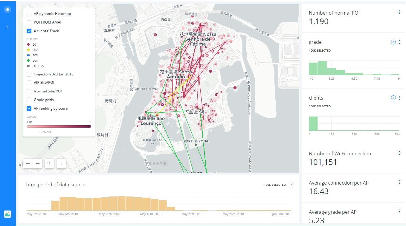
In this project, we focus on the five phases of the WiFi big data in Macau, i.e., data storage, data mining, data analysis, strategies and visualization. We utilize WiFi big data to: 1) categorize resident, commuter and tourist into groups, and then model spatiotemporal trajectories of tourists for semantic mining; 2) identify characteristics and preferences of different individuals and groups; 3) understand the experience of tourists in real-world tourism activities, and Virtual space experience through WiFi connection; 4) Develop personalized travel recommendation service and management system based on Internet geographic information. We finally make a geodatabase to support Web GIS and data mining, a Web GIS-based platform for visualization and analytics and data mining algorithms to provide a customizable solution. Conducted at: Hong Kong Polytechnic University Publications: Coming soon |
|
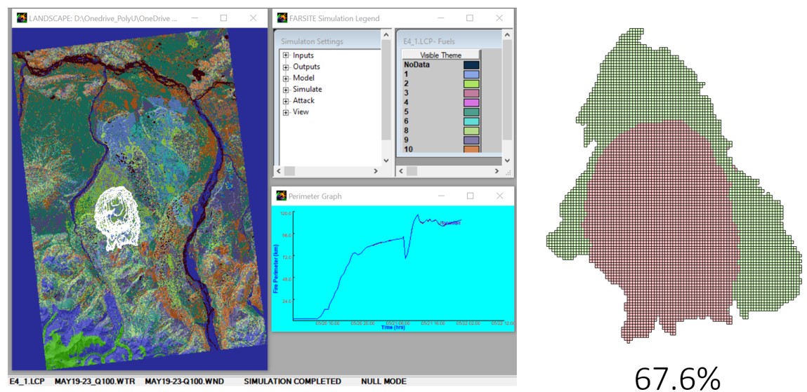
This project aims to develop a versatile, user-friendly, highly integrated data and analytical Geomantic Information System (GIS) software platform for disaster monitoring, analysis and prediction. To achieve the objective above, the project team will leverage on the combined expertise from Hong Kong Polytechnic University (PolyU) in GIS, spatial data analysis algorithm and modeling together with the advanced natural resource monitoring technology from Insight Robotics comprising robotics control and UAV system in aerial survey. The desired outcome is a platform to improve decision making through disaster monitoring using multi-directional visualization system incorporating various data overlay to enable visualization in a multi-factored reality; & disaster prediction based on trends generated from data mining and fusion combined with spatial data analysis/modeling algorithms. Conducted at: Hong Kong Polytechnic University Publications: Journal (Coming soon) |
|
|
Based on the concepts of isovists and medial axes, we developed a set of algorithms that can automatically generate axial lines for representing individual linearly stretched parts of open space of an urban environment. Open space is the space between buildings, where people can freely move around. The generation of the axial lines has been a key aspect of space syntax research, conventionally relying on hand-drawn axial lines of an urban environment, often called axial map, for urban morphological analysis. Although various attempts have been made towards an automatic solution, few of them can produce the axial map that consists of the least number of longest visibility lines, and none of them really works for different urban environments. Our algorithms provide a better solution than existing ones. Throughout this paper, we have also argued and demonstrated that the axial lines constitute a true skeleton, superior to medial axes, in capturing what we perceive about the urban environment. Download AxialGen 1.0 client edition (contact xinao.liu@polyu.edu.hk for user name and password, due to copyright concerned) For a quick starter, follow the video clips (best view in a full-screen mode). Conducted at: Royal Institute of Technology KTH Publications: International Journal of Geographical Information Science (2010) |